Rant Warning – This product contains at least one rant.
Low memory warning – Despite sharing the load with Big Andy, I ran into Severe Post Event Recollection Malfunction – forgive that the records below might show things in the wrong order!

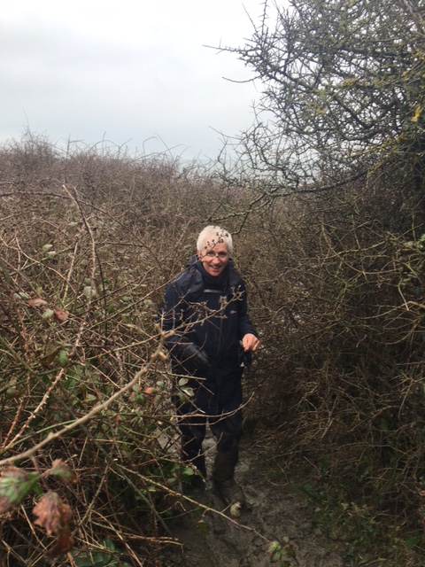
The Blogger – photo by courtesy of Major Big Andy – at Durlston Head lookout. One of the many attributes of walking with MBA was getting pictures of me with a normal expression rather than my posed, stressed, uptight, up close selfies, accentuating facial features best hidden and receding hairline. At least the above merges with the grey sky. I shall be approaching Berghouse for a quid pro quo – Gortex Jacket, Fleece, Over trousers, and two rucksacks – All Berghouse. Otherwise I might be tempted to cover the logo…… that wasn’t the rant.

The Crimson Worms going West temporarily blockaded by the military at Lulworth Cove and Durdle Door, Dorset, on the South Coast; and just entering Exmoor, at Hunter’s Inn, near Martinhoe, on the North Coast. The Maps are by Kind permission of English Nature, with my route superimposed in crimson.
SUMMARY
Merging the finish of the Solent Way and the start to South West Coast Path at Poole; Ordnance Survey Explorer Maps OL22 and OL15
Although, not necessarily reported in the correct chronological order because of memory lapses, this trip went like clockwork, very muddy, but that helped lubricate the parts and everything slipped into place, to enable fifty miles to be accomplished over four days 143 to 146; Sunday,February 21st to Wednesday, 24th, 2016; with Grand Total of 2059 miles. With the outside aid of buses X1 (Milford to Bournemouth) and 50 (Bournemouth to Swanage), two ferries, at Mudeford and Sandbanks ; and the exceptional lodgings afforded by Pete and Pam at Swanage Auberge, for three nights, I have now begun the East entry to the South West Coastal Path, at Poole Harbour, which will take me all the way to Minehead over 600 miles away. I’ve already nibbled a bit off the other end at Hunters Lodge so I’m on my way, and should meet myself somewhere halfway (maybe Lands End?) depending on the prevailing wind. Let’s hope Serendipity continues to rule – OK? And Sunday buses turn up unexpectedly; ferries run to time; the weather behaves and particularly the wind is behind me; and when it inevitably rains there is shelter in the middle of nowhere; and the tides are at a low ebb when I need to cross a beach. All this happened. And the sun shone.
ABOVE – The brambles actually helped stability through the mud, if you didn’t mind a handful of thorns.
. There were many slides and falls but the landings were generally soft, BUT WET. I didn’t complete the whole route from Milford on Sea to Durdle Door because of the imposition of the red flags posted by the army between Kimmeridge and Lulworth Cove. I didn’t want to be shot by a tank, or meet any SBS Gentlemen, so I obeyed the signs and kept out. I will return with reinforcements when they are more receptive – ie on weekends – to fill in the missing piece of the jigsaw.
 Mud! Mud! Glorious Mud! Major mud problems – we brought mudch of it back with us
For one day of the trip I had my own private Army, taking over security and navigation and taking first go at the tricky bits. This was in the shape of Major Big Andrew, all you cousins’ second cousin. Complete with latest gizmos and everything necessary for our safety, comfort and General well being. I could therefore turn off, and concentrate my ailing, aging faculties on grazing, hydrating, moisturising and staying vaguely upright on this very shakey , but enormously impressive bit of scenery. Which gave rise to a number of firsts; of which the premier was never before have I crawled on all fours, or sixes, if including knees, to make deliberate progress uphill – because it was too tricky to stand up. I’m hoping Big Andy has no photographic evidence. But I can confirm there is definitely no photographic evidence of the highly provocative Studland Bay Naturalist Reserve, where peacock exhibitionists strut their stuff in full plumage to the consternation of Ancient Maiden Aunts who , unintentionally or otherwise stray off piste, as it were.. I expected to find a St John’s Ambulance Revival team dispensing smelling salts. The only warning you get is a blue sign saying ” Naturists may be seen beyond this point” – as if it were a rare tourist attraction! Times I wished I had a catapault. I kept my camera firmly under wraps in case I overexposed the negative ….ohh it’s not like that any more – is it?
 .
.
 Angel of the South? Approaching Egmont Point -Berghaus please note I’m sporting four of your products, Gortex Jacket, Over trousers, Fleece lining jacket and rucksack, with complete reserve kit at base – I lost my gloves and forgot my sticks – which probably delayed the mud wrestling walk. But that’s a lot of kit……
Hi Kids!
Are you a bit uncomfortable? Then I’ll begin ….
Dear Rosie, Lauren, Stan, Jake, Rowan and Maisie,
We’re slap bang in the middle of Birthday Parties; Stan’s having his fifth birthday party and second cake this weekend; Jake is four as well this Saturday; and not to be outdone will have several cakes too. And the biggest cake of all will be Nanny’s – which will have to hold at least twenty one candles in two week’s time. And rumour has it all the cousins will be together for Easter at The Mill. That’s a lot of eggs.
HAPPY BIRTHDAY STAN AND JAKE AND NANNY FROM THE SOUTH WEST COASTAL TRAIL
FROM BIG ANDY AND BOBL NEAR CHAPMAN’S POOL.
Note – We’ll have to get Big Andy and Little Andy together to see if the names should be reversed
In chronological order, I began this walk last Sunday by driving to Milford on Sea and heading for Bournemouth along the Romantically named E9 European Long Distance Route via Barton -on-Sea (not to be confused with Barton-on – Humber, where I was two weeks ago) – to revisit Mudeford and little Gundimore, and take the ferry across the mouth of Christchurch Harbour to Hengistbury Head, whose corner I turned and headed for Boscombe and finish the day at Bournemouth Pier. And the last Sunday Bus to Swanage Auberge, which I boarded with minutes to spare after fourteen miles walking. Timing!


The E9 European Long Distance Coastal Route with strong winds blowing straight off the sea made the going quite bleak. The warning tells of wartime metalwork being exposed as the coastal erosion bites chunks out of the land. Today the strong winds were heading straight off the sea – making headway was hard going.


ABOVE – The bleakness turns gradually to expensive property prices as I head for Sandbanks -£89,950 for a beach hut – at Mudeford. Where resides Little Gundimore, a listed building, which I worked on for Terry Smith with Danny Fox , Peter and Daniel Hall many years ago. Memories dim but the main pre-occupation was protecting the carpets and piling all the furniture in one room; as work progressed then moving it to the next room; and so on. At the end when no more rooms were vacant we threw it in the biggest skip ever; much bigger than the one below. And the carpet too!.

Little Gundimore


Above – From top to bottom ; the Ferry journey from Mudeford Quayside across the Christchurch Harbour entrance with the first mate tieing up on the sandspit side heading for Hengistbury Head.


ABOVE – Life on the other side of Christchurch Harbour- Hengistbury Head – plenty of sand and British Rail might look at H S 99 Altho’ it’s already very green……


Beach balls – Sand migration seems to be endemic approaching Bournemouth – better than erosion though

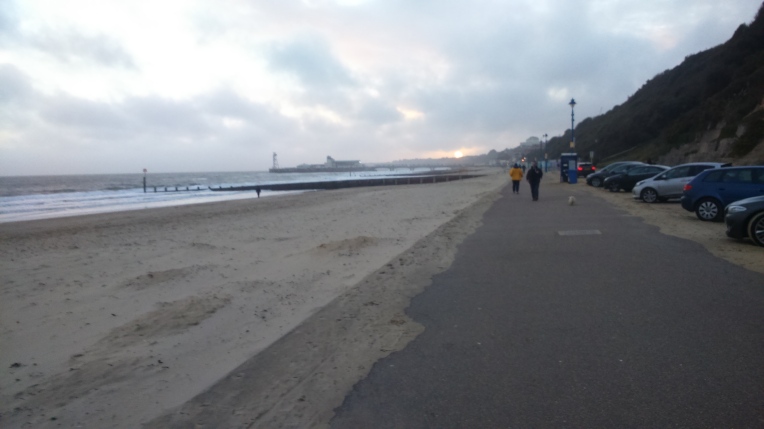
ABOVE – Approaching Bournemouth Pier at five thirty pm – in a hurry – Sunday bus to catch at 17.41pm and I don’t know where the bus stop is! No time for any more photos.
I made it – now on the X1 bus back to the car at Milford on Sea. I’ll be back in Bournemouth shortly. But first I’ve got to establish contact with Pete and Pam, at The Swanage Auberge Bunkhouse, where I’m staying for three nights. It turned out to be perfect for what I’m doing and the accommodation excellent value. It’ll spoil me for camping. Memories of Youth Hostelling……


But Big Andy arrived on Monday and a chance to make progress along the South West Coast Path. We drove to Kimmeridge Bay, on the edge of Lulworth Range Danger Area, – O/S Explorer Maps description – not mine! And left his car in the biggest, emptiest CarPark and trusted to Andy’s memory where to find it again. The plan was to walk back the twelve and a half miles to Swanage and return in RAV4 to find his vehicle so he could drive home. As I said earlier , I’m taking the day off from memory type tests.


The gruesome twosome at isolated Kimmeridge Bay Car Park with the view of Clavells Tower Folly, listed building built by Rev John Clavell in 1830, as an observatory and folly. The other views show the S W Coastal Path terrain.


Monuments , obelisks, milestones and posers around and about Chapman’s Pool.

Royal Marine Monument 1945 -1990


The South West Coast Path around and about St Alban’s Head, the Lookout Station and National Trust territory at East Man and in the distance Anvil Point Lighthouse guarded by Hereford cattle, and the milestone to Durlston and Langton.


Durlston Head Castle and Globe with milepost to Anvil Point, and the old entrance to TillyWhim Caves – old limestone workings that used to be tourist attractions well over a century ago.


Approaching Swanage towards the end of the day’s walk with Big Andy. Passing Peveril Point and Swanage Pier. We had trekked twelve and a half miles through very muddy conditions so it felt like a lot more – and there were many steep ascents and descents – wished I hadn’t forgotten my sticks! Some pictures were taken revisiting the day after because it was getting too late, including the one showing wrecksites around the Poole Harbour Area.. seems its quite dangerous out there.
Andy and I finished with the obligatory Guinness at A Swanage Pub, helping to get the tiredness out of our legs – the mud seemed to double the distance. By the time we decided it was time to retrieve Andy’s car back at Kimmeridge Bay, it was very dark. Andy was totally entrusted with navigation and the only alarm we had driving through the Isle of Purbeck to retrieve his car, was finding the gates to the carpark shut and notices declaring this was private property. Alarm Bells! Andy tried the gate and it swung open – We took the only car there, fortunately it was his, and headed back home – well – Andy back home – me back to the Swanage Auberge. It was a pleasure to have his company and experience as guide – I relaxed and enjoyed the free ride – by taking far too many pictures – and now trying to edit them. It was also strange having company for the whole day; and almost seemed sensible in the middle of nowhere. I hadn’t given that much consideration before.
But the late change of itinerary afforded by Big Andy’s Presence, taking Kimmeridge to Swanage out of order, was a huge bonus in terms of progressing the walk but my schedule was now out of kilter and I find it difficult now to piece together the actuality. I have to be very strict with myself to adhere to the proper route and ensure, at the end of each session I have covered the total course and link up with previous finish points.. I don’t want any doubts that I may have missed bits or taken short cuts in my trip round England. It would be pointless! Sometimes I deliberately overlap more than the required amount to satisfy my OCD.


Approaching Old Harry Rocks along Old Nick’sGround and round The Foreland or Handfast Point. The National Trust certainly lay claim to some fabulous Naurel scenery. Compare and contrast with the industrial scenery – below – taken from the top deck of the Breezer 50 Bus (open top) returning to Swanage after walking to Bournemouth pier from the south; waiting for the shipping to pass across the chains of the chain ferry at the entrance to Poole Harbour at Sandbanks , but another ship came by slowing our progress to South Haven Point. Never mind – every silver lining has a dark cloud – in this case the guy sitting up front – top deck – foghorn voice- in addressing the lady next to him , in fact the whole top deck was included – had an APP that enabled him to tell us the total navigational history of the ship ahoy, that it was a new service from the continent laden with semi- trailers but no driving units and the Captain’s inside leg measurement. Here started a discussion on the why’s and wherefores of the new shipping route. Uptil now (like until but heavier going?) I had bitten my tongue and kept quiet as their conversation foghorn had boomed that all NZers were Racist; (I’M NOT – Remember Little Andy was born in Takapuna! – so can’t be?) – they cast aspersions on the West Midlands and generally had something to say about anything else I had ever been involved with). It turned out to be a two hour bus journey with all the delays – so I got to hear his AND her career path ups and downs – Dear Reader , you’ve got the blog to bore you – take it from me you don’t need to hear the teaching career morphing into … whatever …. ahhh my selective memory has returned and I’ve forgotten. Anyway I needlessly defaulted into the conversation, by adding the bleeding obvious that the new route was by-passing port troubles at Calais. The lady immediately wanted to know what APP did I consult for this information? Apparently no approbation appears until approved by appropriate APP. I only mention this as contrast to my normal walking mode of isolation – Sandbanks for me will always be tinged with enforced earbashing in carcerated in an open top bus top deck on the mid-deck of a chain link ferry stranded in port. Give me the freedom of the shoreline anytime…..
Rant over – return to out-of-sequence pictures of Bournemouth Pier, which was where I was returning from!


ABOVE – Entrance to Poole Harbour -This was the second ship that delayed the ferry at Sandbanks – home of ‘Arry – taken from the top deck of the open top bus whilst waiting on the chain ferry deck earwigging inappropriate conversations.
I’m not necessarily worried that I find it quite arduous piecing together all the detail to record the blog in logical order – I put it down to handling a huge amount of new information relentlessly – after spending days beforehand researching transport, weather, accommodation and the route. The only surprise to me is how much serendipity plays an enormous part. Not luck – I won’t say I leave nothing to chance, but I do a lot of homework and the more I do, it seems the more serendipititious I get. But I am conscious now of my limitations, and that they are not improving as the walk, fortunately, is hopefully into its final third.
This is all by way of saying I have an enormous amount of material accumulated over these last four days of walking and, whilst not wishing to over promote my photography skills, I find it very difficult to choose what to leave out, so I’ve included most of it – most of it uncaptioned – so take it from me – all the following pictures were taken somewhere between Milford -on – Sea and Durdle Door. But none on the Military Danger Zone between Kimmeridge and Lulworth Cove. Good Luck!


Lulworth Cove and the start of the Path towards Durdle Door – how can I leave any of these out?


Leaving Lulworth over Hambury Tout and arriving at Durdle Door – as far as I got this trip – and now the return to the car at Lulworth via the beach……


That was a long trek over the beach round St Oswald’s Bay, with a set of fresh footprints to guide me – I didn’t know for certain that I could get out at the other end, but the tide was at its lowest ebb and the map showed footpaths to Dungy Head.The exit to Lulworth Cove was steep and slippery, but this time I had my sticks. And soon I was reunited with my car and heading north for Shropshire.

Reminder that there are over 600 miles to go on the South West Coast Path


The approach towards the chain ferry from Studland to Sandbanks

Two miles after Old Harry Rocks – heading for Old ‘Arry’s pad on Sandbanks. And Spurs go marching on ….. Dare to believe?


")


